Hi! I've just purchased the basic version of the programme for an Intel Mac and am currently adding all my chart data. I have a few questions which I can't find answers to in the Help pages, so I'm going to post each of them here under their relevant subject headings.
I'm having some problems with adding locations to my own atlas, so have some questions about this. I've been through the tutorial. There's no problem with adding the locations themselves, just in getting them to display correctly and consistently in the atlas.
First question:
I select a town from the mini atlas in the same region/timezone, eg London, England. I save this to an individual's data, then click [Add]. In the window that follows, I change the lat/long to the correct coordinates in the top section of the window.
If I then change the name of the town at the bottom of the top section of the window, just including the name of the town only as it says to do in the tutorial, then click the [Add] button next to it, the resulting display is Town ((nul)) and ((nul)) in the country box.
If I change the name of the town, but leave (England) following it, then the resulting display is "Town (England), England" with United Kingdom in the country box. If I then highlight and delete both of the "(England), England"s and press [Change], the display finally comes up as it should -- "Town, England" with United Kingdom in the country box.
How do I get this right first time?
Second question:
I've now added a selection of English towns all starting with London. After going through the above rigmarole, they're all now displaying OK. However, one town is displaying a different timezone, despite me using London as the base town every time. All the towns display 0hw00:00 except this one which displays 1he00:00. It doesn't seem to impact the chart since the Asc is correct.
Why does it display differently?
Finally, third question:
It says in the tutorial that the USA and International atlases are greyed out in the *trial* version of the program. I purchased the mini atlas personal edition, but the USA and International buttons are still greyed out (even though the locations seem to be available in the mini atlas).
Is this correct for the package I've purchased?
If anyone can cast some light on any or all of these questions, I'd be very grateful.
Atlas questions: custom displays, timezones, etc
-
wendyh
- Posts: 10
- Joined: Sat Feb 24, 2007 11:16 am
-
mehemptah

- Site Admin
- Posts: 379
- Joined: Tue Sep 29, 2015 7:42 pm
- Contact:
dear wendyh, thank you for purchasing kairon.
the tutorial on how to enter a town is based on version 3.03. meanwhile you can just go and add a town and while you are at the edit spot it is still possible to change the city on which the new one should be based. So, it is the other way round now. When a town's zone displays wrongly, it is wrong and you also get wrong calculations. your one minute of arc question already indicates this. you won't see the difference with slow planets like jupiter, saturn and the like, but will notice with sun, moon, venus and especially with the ascendant.
the mini license uses the mini atlas, this is why it is called mini license.
the full license uses the full atlas, this is why it is called full license.
full licenses allow downloading the full ACS Atlas which contains over 250.000 cities while the mini atlas only contains about 9.000 cities.
you can upgrade to the full atlas from inside the application, this unlocks the international and us radiobuttons, but before clicking them the new Atlas must first be downloaded and installed. Kairon will keep searching for that Atlas otherwise ...
best wishes,
kilian
-
wendyh
- Posts: 10
- Joined: Sat Feb 24, 2007 11:16 am
Thanks for your reply, but I'm not sure you answered my question. I'm still having difficulty making my additions to my own atlas 'stick' correctly in terms of their full location. I've tried adding the data in quite a few different ways but I've yet to manage to get the location, region and country to display correctly first time.
I know the full atlas is vastly superior, and I will upgrade once I'm certain that this program can do all the things I need an astrological program to do, but I'd still like to understand how to use the custom atlas properly.
The questions I posted here are all questions I had after going through the online tutorial thoroughly and being unable to find the answers to them there.
My one minute of arc question is based on having used identical lat/long location data to what is used in Astrodienst's software -- or at least what is displayed on a printed Astrodienst chart. If, eg. Astrodienst display lat/long rounded to the nearest minute while including greater precision in the underlying data, then that might explain the difference.
-
mehemptah
- Site Admin
- Posts: 379
- Joined: Tue Sep 29, 2015 7:42 pm
- Contact:
the calculation question can only be discussed by copy pasting the AAF Data from Kairon and by showing the data Astrodienst used as well. only this way i can recalculate. Kairon uses the Swiss Ephemeris as the Astrodienst website does, so there is no difference inside, the only difference is the processor of your mac and the entry of calculation data. rounding can be judged only from the example as well. generally, astrologers are rounding down, not up, while Kairon prefers to be as scientific as possible. it casts a graphic view on the phenomena in the sky, rather than a categorical view. the categorical view has got to do more with interpretation, while the graphical view is the much truer one. imagine you hold your hand on a hot surface. it burns. imagine, you hold it very, very close. optically it is already there, but categorically still not. so 1°59'59" is by 59" nearer to 2°00'00" than to 1°59'00". The custom of generally rounding down has been created after the discussion: while 29°59'59" Aries is only 1' off from Taurus, it is still Aries, while 0°00' Taurus is no longer Aries, which 29°59' Aries still would indicate, although the inexactness is 58 times greater! It is the point of getting lost in detail and loosing the context.
Atlas: if all permissions are truly read and write of the private Atlas file and its folder, then you should try the intuitive way: click "add" to add a new location, look at all the buttons and make up your mind what they micht mean and read the sheets that are coming down: these sheets DO tell you what to do. really, and it works ((delete what is written in brackets and it won't multiply))
best wishes,
kilian
Atlas: if all permissions are truly read and write of the private Atlas file and its folder, then you should try the intuitive way: click "add" to add a new location, look at all the buttons and make up your mind what they micht mean and read the sheets that are coming down: these sheets DO tell you what to do. really, and it works
best wishes,
kilian
-
benbonben
- Posts: 3
- Joined: Wed May 13, 2009 11:27 am
As I understand this, you did not answer any of the questions. I have the same questions. I would like them to be answered.
Entering cities did not get easier. In fact, I still don't even have access to 9 000 cities : I can get about 30, from Yuba City to Zwolle. The zip of the Atlas does not seem to work right : it only unzips to an unreadable cpgz file. Double-clicking does nothing interesting ; Ditto does not seem to recognize it.
For what I can see, the claim that registering gets you the USA and Int boxes available is simply false. Rehearsing the definitions of Full and Mini is worse than not answering. It is implying that we should buy the Full atlas for the problems to disappear. But when faced with this kind of answer and strange GUI behaviour, why would a rational being (more so if he's a Taurus) risk money ?
I am still under the 30-days refund policy of Kagi.
-
mehemptah
- Site Admin
- Posts: 379
- Joined: Tue Sep 29, 2015 7:42 pm
- Contact:
dear benbonben,
thank you for purchasing kairon.
i am sorry, but if i should have a chance to help you, you will need to be more specific.
why on earth should anything have changed about the application by entering the license key? it just unlocks the application so it doesn't run out of time. the kairon policy is: try before you buy.
it is that simple. nothing will ever change by buying either of the two mini versions. only the full version give you access to the full atlas, and of course you can't find the atlas because you don't have it yet, it is a further download. as you purchased a mini version, of course you only have access to the mini atlas.
for any difficulties with the application there are two basic reasons:
a) wrongly set permissions during the installation process, you need to see to it, that the logged in user is the owner of the kairon folder itself and of all the files therein, otherwise changes of the settings won't take place, nor will the atlas ever show new cities, because you don't have writing access. (if a city was entered wrongly, it is a useage error, but if it was not added at all, it is a permission error)
b) not following instructions in detail
why a mini version at all?
there are some people who don't do many charts, and who will not have to enter more than a few cities... it would be unfair that they should be forced to buy the entire atlas, when they don't actually need it.
i don't know what made you think you would get the full atlas by registering the mini version, please give me a hint, so i can reedit the text there to prevent further people from thinking so.
why risk money?
you risk only, if you don't try.
Kairon comes with NO restrictions at all, so if you don't like it the way it is, you will not like it after registering either, and if you like it before registering, you will also like it thereafter, because it won't change.
Only change is: you get 250000 cities more by registering either the full private or the full professional version, or by upgrading to either of them.
you can't say i don't answer questions in general... please be exact, to give me a chance to know what to answer. i am patient, but not allknowing.
-
benbonben
- Posts: 3
- Joined: Wed May 13, 2009 11:27 am
Too many issues. Let's deal with two :
1. The Mini Atlas I have has 30 cities, not 9000. Why?
2. Also, The documentation says that :
<<
To find a Location in the "ACS-Atlas", select an atlas first. In Kairon's 30-launches demo (which can be launched 30 times with full functionality before entry of your personal license key is required to continue its use) the "USA" Atlas (>150.000 US locations) and the "Int." (>100.000 International locations) are greyed out and cannot be used.
>>
This is not the case. I have a registered version. It is still greyed out.
-
mehemptah
- Site Admin
- Posts: 379
- Joined: Tue Sep 29, 2015 7:42 pm
- Contact:
ok, this is a good idea:
1) you have the full number of cities, but they only show up, while either entering letters into the search-field (see red arrow) or while clicking the up- and down-steppers (see red circle)
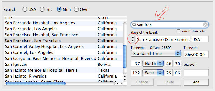
2) it is true, it is greyed out.
(and it stays greyed out unless one upgrades to either of the full licenses)
1) you have the full number of cities, but they only show up, while either entering letters into the search-field (see red arrow) or while clicking the up- and down-steppers (see red circle)
2) it is true, it is greyed out.
(and it stays greyed out unless one upgrades to either of the full licenses)
-
mehemptah
- Site Admin
- Posts: 379
- Joined: Tue Sep 29, 2015 7:42 pm
- Contact:
Atlastutorial Extension
here http://kairon.cc/files/atlassearch.html is an extended explanation with pictures on how to add towns to the atlas, i will explain the "Calculator" as soon as i can the same way. 8)
-
benbonben
- Posts: 3
- Joined: Wed May 13, 2009 11:27 am
That answers my two questions in a very neat and concise manner. I can even see a step-by-step example ! It also answers the one about adding a new city, as it seems to be related to the atlas. It is so good, in fact, it should be put in the tutorial. I am more than happy to stand corrected !
Many thanks for providing these additional informations !
Many thanks for providing these additional informations !